System: Live updates have not connected yet.SYSTEM / 2140STANDBYLogin
Retrieving destination…
Intercontinental Transatlantic
Accessing sector.
Loading destination. Please stand by.
Touros Gateway Registry / 2140
Touros South Atlantic Gateway
The Brazilian gateway connects Atlantic arrivals to railside cargo handling and regional distribution. Its 30 terminal tracks retain their registered alignment. Freight reception, headquarters and support occupy six separate inland precincts.
BR / CARTOGRAPHIC RECORD
Terminal atlas
Atlantic arrivals. Railside handling. Northeast distribution.
REFERENCE EDITIONBR / 01Touros South Atlantic Gateway / Touros terminal
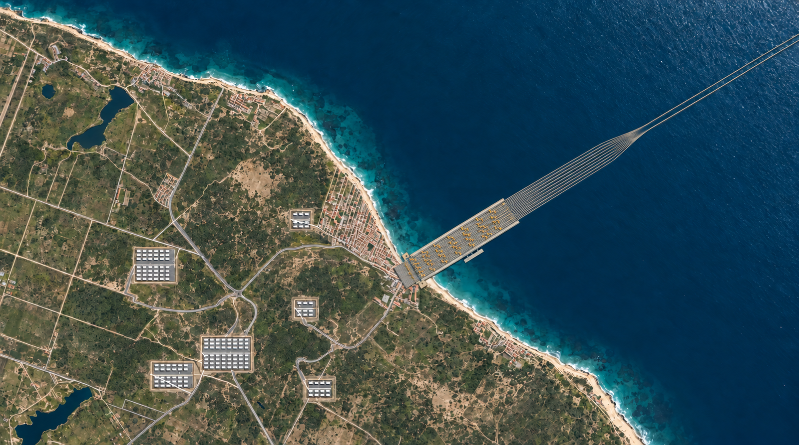
Illustrated Touros gateway over the mapped coastline, town and roads. Proposed ITA handling structures and inland precincts belong to the 2140 scenario.
Drag to explore · Pinch or Ctrl + scroll to zoom · Keyboard: + / −, arrows, 0 for overview. Position and zoom are retained between views.
Select a landmark to locate it across the five drawings. Numbers refer to visible features in this edition.
Illustrated positions. The bridge and railway retain their separate geographic register.
Street directory 31 named streets
Mapped roads retain their Portuguese proper names. ITA access streets are fictional additions for 2140. Select a street to locate its traced alignment; zoom in to read nearby names.
Coast, town and inland operations
The geographic base preserves the mapped Touros coastline, lakes, streets and buildings. Proposed ITA access roads link the inland programme to the regional road network. The offshore service quay is a new concept facility; the drawing does not portray Touros as an existing industrial port.
ITA concept precinct / 2140
Atlantic transfer terminal · 0.200 km²
Customs, cargo reception and covered transfer halls southwest of the town. A separate underground cargo link connects to the railway collector without creating a road crossing over the arrival tracks.
ITA concept precinct / 2140
Northeast distribution estate · 0.960 km²
Freight warehouses, truck staging, cold-chain storage and regional distribution. Proposed industrial access roads connect to the mapped road network serving BR-101 and RN-023.
ITA concept precinct / 2140
ITA South Atlantic command · 0.180 km²
Gateway administration, railway coordination, records and technical training. Visitor and staff entrances remain separate from freight handling.
ITA concept precinct / 2140
Gateway military support estate · 0.800 km²
Separate command, barracks, workshops, medical support and emergency staging. Staff transport serves civilian entrances and does not enter the controlled estate.
ITA concept precinct / 2140
Continental freight reserve · 0.600 km²
Reserved reception and consolidation precinct for future continental freight connections. No existing mainline railway at Touros or acceptance of 2 km trains on the Brazilian network is asserted.
ITA concept precinct / 2140
Gateway energy and maintenance · 0.240 km²
Power conversion, water services, maintenance stores and technical support, separate from the cargo reception halls.
Areas include yards, internal roads and setbacks. This fictional 2140 programme does not establish present-day ownership, environmental clearance or engineering approval.
From train to inland terminal
Fifteen paired-track modules serve all 30 berths. Each module has nine mobile gantries with a 30 m span, a 10 m transfer strip and a 6 m automated cargo lane. The 2.2 km working strips accommodate a 2 km train and its end clearances. Two outer aprons and lateral transfer halls support the operation.
Cargo passes from wagon to gantry, transfer lane and lift, then through a collector below the railway deck to the shore tunnel. This arrangement creates no level crossing over the active tracks. The approach fan, original rail coordinates and buffer stops remain unchanged.
The 240 × 30 m service quay supports the proposed offshore estate. Structural elevations, coastal interfaces, lifting capacity, navigation and tunnel gradients require engineering definition. Continental reception is a future reserve, not a claim of an existing railway connection or compatibility with 2 km formations.
Five views share a 20.00 × 11.16 km north-up frame. Network and the 2D plan project geographic vectors directly. Satellite and terrain are illustrations of that plan; traffic and staff transport are proposed overlays. Descriptions, street labels and scale remain in the interface.